"Blacks Ferry” History
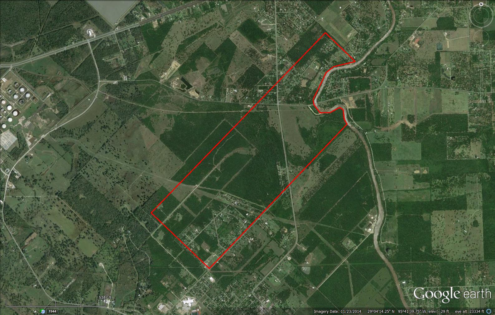
James E. Black bought 1000 acres from David McCormick in the McCormick League in 1845. It is said he paid $10,000 in gold coins, got the land, two boats and a household (see Pat Ellis article). The deed for this transaction was never found. It is also said McCormick had started a ferry in 1824. From this point, James Black continues the ferry, develops his plantation and builds a sugar house, thus the beginning of the name and history of “Blacks Ferry”.
The approximation of James Black’sPlantation
This San Bernard River ferry crossing was the primary route connecting Chances Prairie to Columbia (East Columbia) and Brazoria for transporting plantation crops and people.
Following Black’s death in 1858 his estate was probated and partitioned between his estranged wife Sarah, two minor sons of him and Sarah and two children from a previous marriage. His estate included the 1000 McCormick acres plus the ferry as well as 600 acres in Walker County. Sarah and the minor children received the 1000 acres with the ferry with Sarah getting 600 acres and the boys splitting 400 acres that included the ferry and ferry landing. The children from his first marriage got the 600 acres in Walker County. It is thought that Sarah and/or the boys operated the ferry until her death in 1864 and at least one of the boys did up until 1870 when he sells his 200 acres with the ferry landing, boat and all associated animals and rigging to Vincent Tureni.
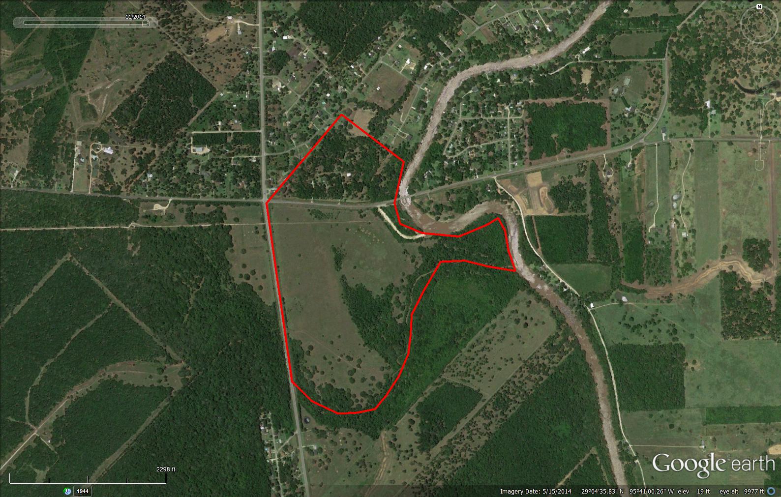
Tureni operated the ferry until his death in 1883 and the place became known as “The Tureni Place”. In August 1883 William L Sweeny (son of Jordan Sweeny and grandson of John Sweeny Sr.) acting as administrator for the Tureni estate sells the 200 acres in a public auction on the steps of the court house to his brother J. W. Sweeny. The land is described as 200 acres with improvements including a ferry and ferry privileges and the homestead of Tureni, where he resided at the time of his death and known as the “Blacks or Tureni Place”. On the very same day J. W. Sweeny sells the 200 acres back to William Sweeny. William L. Sweeny owned this land up until his death in 1923 living on it most of that time. He also operated the ferry part if not all of this time.
The approximation of the 200 acres Tureni and later William Sweeny Owned
Picture Identified as “Blacks Ferry” by BCHM
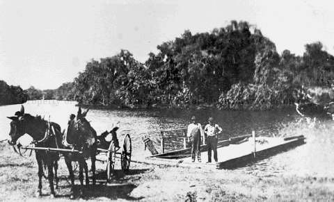
Image courtesy of the Brazoria County Historical Museum
“Blacks Ferry” Crossing With House in Background
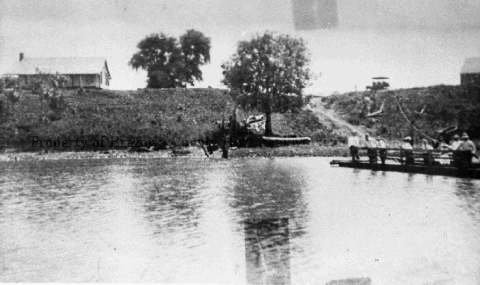
Image courtesy of the Brazoria County Historical Museum
Picture Identified as “Blacks Ferry” Crossing by BCHM
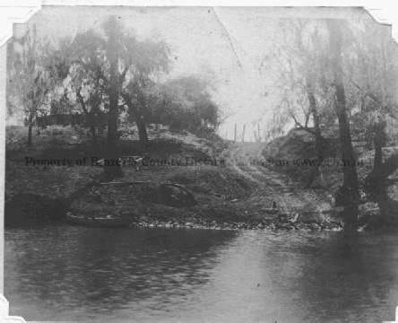
Image courtesy of the Brazoria County Historical Museum
Research of “Commissioner Court Minutes” show in 1890 he was approved by the county to operate a ferry. In 1911 he was awarded a contract by the county to operate a free ferry. Although beginning in 1907 he did have liens against this property plus notes from Larkin Waddy whom he had sold other land too, this was resolved in 1913 and he retained ownership of his land. It appears the liens were the result of a court case involving common school funds (taxes).
Following William Sweeny’s death his estate was split up with the Bannister/Holland clan ending up with part of the 200 acres. Ultimately Lone Star Salt Water ends up with all of it.
Land disputes appear to be common during this time period and this land was no different. In 1873 the estate of Sarah Black sold her 600 acres to a Burke or perhaps Brooks (document very hard to read). This sell was challenged in court. The challenge failed. However, to arrive at a decision a survey was done to establish the dividing line between Sarah’s 600 acres and the boys 400 acres. The starting point for the survey is described as on the west bank of the river on the north bank of a bayou (we would now know this bayou as the sulfur ditch) and just below an old house. In March of 1890, A P McCormick son of the first McCormick had the original 1000 acres re-surveyed because some unnamed parties had expressed interest. Within the first several callouts on this survey that start from the
river corner between the McCormick and Keep leagues calls for crossing a bayou (sulfur ditch) passing a sugar house and one point a stake in the yard of a dwelling house.
“Early Sweeny Nesters” from the 1910-1920 eras talked about walking to Black’s Ferry and going by a house with a bear tied to a tree.
Same House as Previous Picture, Different View
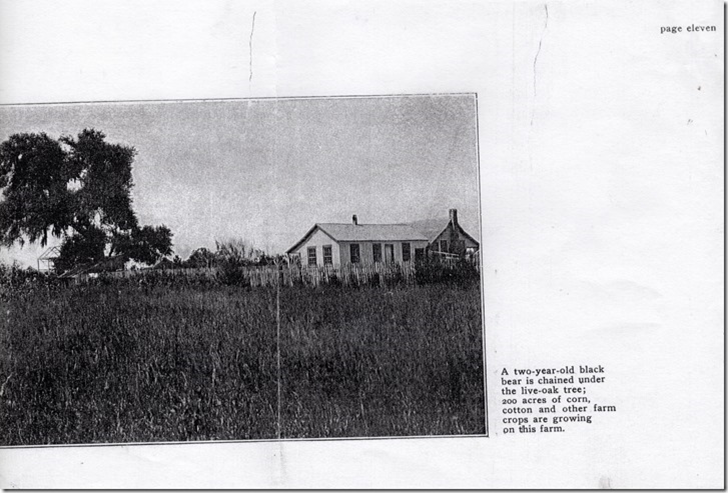
Image courtesy of Charlene Finley
They also talked about Mr. Black losing the ferry due to politics or even having it stolen from him. The bear tied to tree is easily understood since bears were prominent in the area during this time. As for Mr. Black losing the ferry, he died in 1858, so the question becomes how or why did William Sweeny lose the ferry? After researching land records back to the 1830’s and Commissioner Court minutes back to the 1860’s this question remains un-answered. In fact it is unclear exactly how long any ferry ran at this location after around 1911-1914. The land disputes took place pre 1900 and it is known William Sweeny retained this land until his death in 1923 so this had nothing to do with him losing the ferry. There were two ferry companies incorporated in 1884-1885 to operate ferries across the Bernard. One of which, based on the description, was to operate at this location. The other was to operate at the “Ludders Ferry” (this has been spelled Lutter and many other spellings) location which was up river in the vicinity of where Hwy. 35 is now. Interestingly, William Sweeny was part owner of this company so it appears he was involved with two ferry crossings. No evidence was found that would indicate the other ferry company ever operated at the “Blacks Ferry” location. We also know William Sweeny was granted a contract by the county in 1911 to operate a free ferry. Beyond 1911 up until 1947 no evidence of what took place at “Blacks Ferry” was found in the records with the exceptions of numerous Commissioners Court petitions in 1913 and 1914 by T L Smith and others to install a bridge or free ferry. William Sweeny also petitioned Commissioners Court in 1914 to build a bridge here with the carrot he would finance it. Commissioners Court approved his petition, went out for bids, but rejected all bids when they were returned.
In 1912 Sweeny was also involved in getting the first county road from the town of Sweeny connecting to the Brazoria to Chances Prairie road that crossed at “Blacks Ferry”. In fact he was paid to clear the land for the road.
Proposed Sweeny-“Blacks Ferry” Road
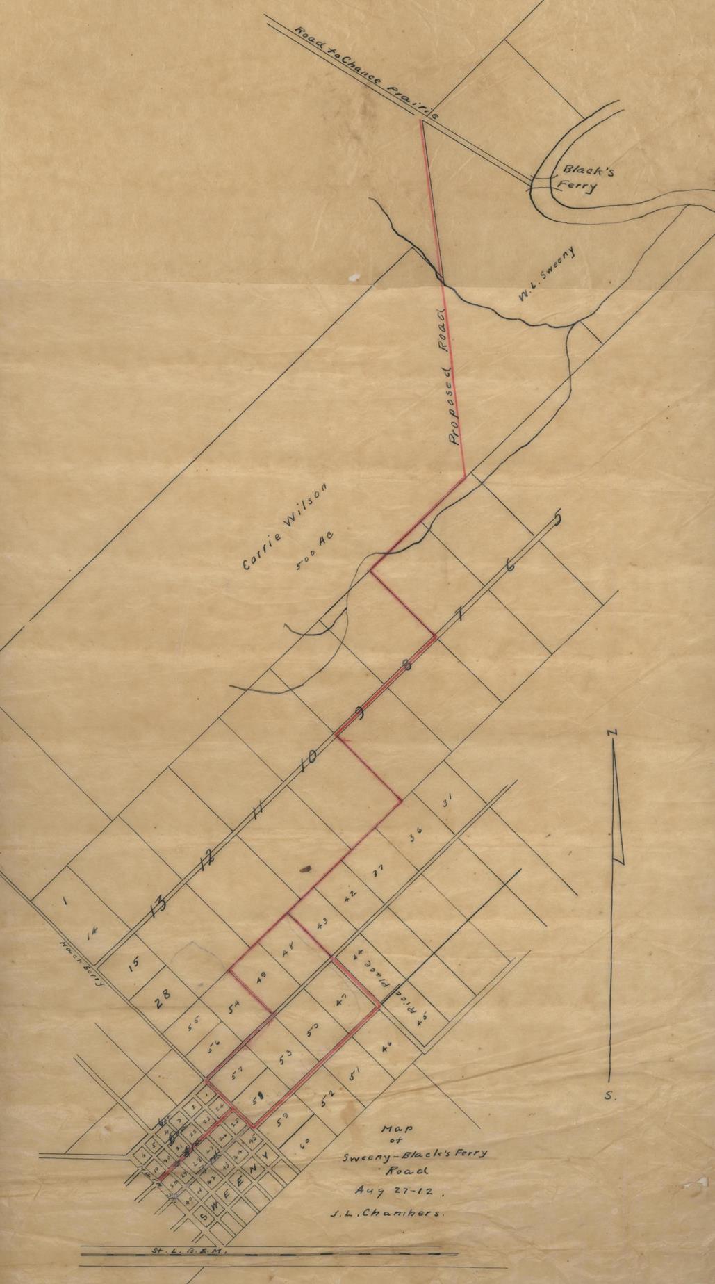
Image courtesy of the Brazoria County Historical Museum
County records go silent as far as crossing the Bernard at “Blacks Ferry” up until 1946 when the county entered into an agreement with J. S. Abercrombie Company to construct a pontoon bridgeacross the Bernard at “Blacks Ferry”. The bridge was constructed and opened in 1948. The current bridge was opened in 1957.
The mystery of if, how or why William Sweeny lost the ferry remains unsolved at this time. In fact exactly how long any ferry operated there beyond the 1911-1914 time frames could not be determined with record searches. Commissioner Court Minutes provide bread crumbs to follow such as contracts to operate ferries, bridge contracts, ferry operators on those ferries operated by the county etc. at El Bernardo, Hinkle’s, Churchill and others on into the 1950’s, but nothing on “Blacks Ferry” until the pontoon bridge. One suggestion might be that the usefulness of a ferry at this location had expired. With the train thru Sweeny up and going in 1906, El Bernardo having a bridge in 1910, roads connecting Sweeny to West Columbia via “Ludders Bridge” by 1913, other routes for moving people and crops across the Bernard had been established.
Another interesting item about “Blacks Ferry” is the little known Black family graveyard located by Henry Hanson and others. It seems odd that the location of it is not on the original plantation. Hopefully we can develop more history on this in the future.
Blacks Graveyard Location
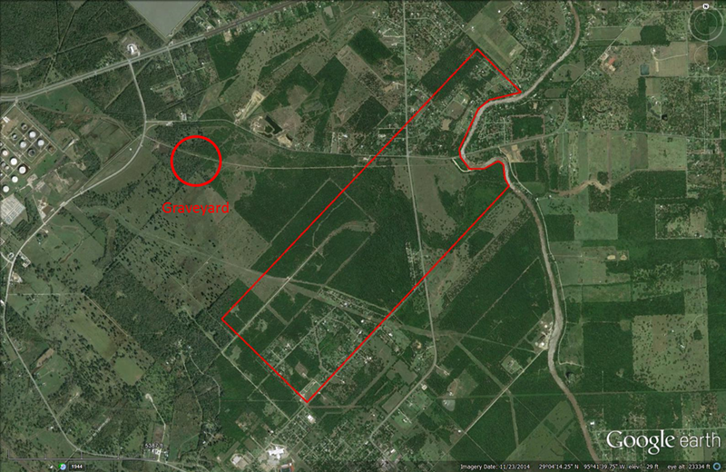
Image courtesy of Henry Hanson
Thru the years “Blacks Ferry” has been an important part of Sweeny’s history. In the early days it was the primary route from getting people and plantation crops from the plantations of the Sweeny’s, Armstrong and Black across the Bernard to Columbia or Brazoria. It was the home of William Sweeny who would later become the post master of Sweeny as well as become involved in the development of Sweeny from roads to schools to the town site.
“Blacks Ferry” has also been known as a place where baptisms took place and of course a favorite swimming hole for the youth of Sweeny for years to come and continuing until this day.
Some interesting facts uncovered during the research.
·
There have been no fewer than eight public Bernard River ferry crossings in Brazoria County over the years. Not all at the same time and some with different names at times. Each location also had at least one bridge at some point. From wooden bridges early on, to iron draw or swing bridges to where we are today. In the early days the life of a bridge was short due to storms and floods.
·
Locations of ferries and bridges
o Up near what is now C.R. 1301, one time called “Lonis or Overland Ferry”
o At Hwy. 35 location called “Ludders Ferry”
o “Blacks Ferry”
o “El Bernardo bridge and later Ferry”
o One near Shaddy Acres called “Overmans Ferry”
o “Mims/ McNeil Ferry” near Hwy. 521
o “Hinkle’s Ferry”
o “Churchill Ferry”
·
Some plantation owners also had their own ferries. In fact John Sweeny Sr. had a ferry landing very near if not exactly where the heavy lift contractor is currently offloading barged in plant equipment.
·
In the early day’s bridge keepers were assigned to all bridges with the responsibility to keep the bridge maintained and lighted, operate the draw bridge if it was one and most were at the time, keep drift wood from taking out the bridge and limit the amount of livestock crossing at the same time.
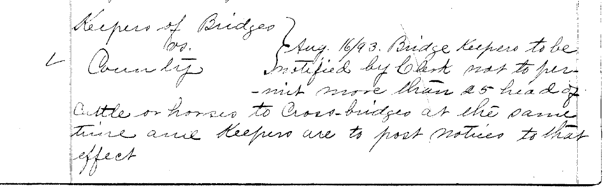
From 1893 Commissioner Court Minutes
The first two iron draw bridges were at the Ludder’s and Mims locations. Both built in 1892 and both taken out by an 1899 flood.
·
The last two operating ferries were at El Bernardo and Hinkle’s, both operated into the 1950’s.
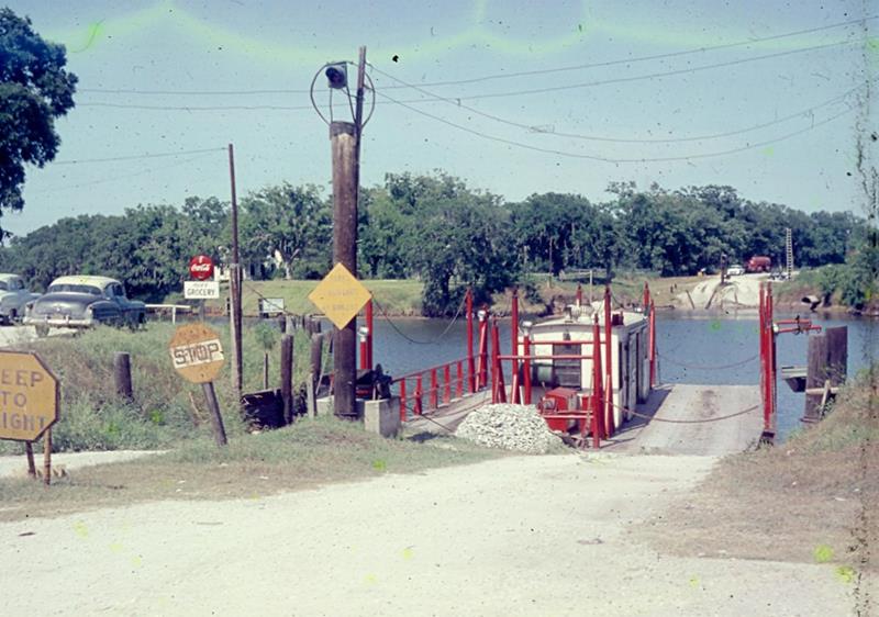
Hinkles Ferry 1956 Image courtesy of the Brazoria County Historical Museum